

Reading Coordinates Systems: Lat/ Long
For example: Where is (39 point 33 point 03, 119 point 49 point 21) ? Or how about (39 point 33 point 052 by 119 point 49 point 355) ? The correct answer is “Nowhere, because these are nonsense interpretations of a lat/lon readout from a GPS”. There is no system which has that many “points” in it. If you get a location which has more than one “point” in each part of the location, then you know that the sender has made a mistake.
There are three common formats for lat/lon locations: degrees/decimal degrees; degrees/minutes/decimal minutes; and degrees/minutes/seconds or degrees/minutes/seconds/decimal seconds. Recognizing and reading these three formats is explained below.
Remember that in lat/lon, the world is divided into 90 degrees of latitude running “up” the globe from the equator to the North Pole, and 90 degrees running “down” the globe to the South Pole. We also have 360 degrees of longitude which connect from pole to pole. Each degree is split into 60 minutes, and each minute is split into 60 seconds. Right there we get another red flag: if somebody reads a coordinate with more than 60 minutes or more than 60 seconds, we know that they are confused.
Degrees are noted with the symbol o . So 39 degrees is shown as 39o.
Minutes are noted with an apostrophe or feet symbol ‘ . So 39 minutes shows as 39’.
Seconds are noted with a quote sign or inch symbol “ . So 39 seconds shows as 39”.
We always want to be as precise as possible, and the GPS and computers we use give us details down to very fine resolution so there will almost always be a decimal thrown in somewhere, depending on how new or fancy your GPS is. To properly read the decimals as they would be used in the common lat/lon formats, let’s look at the intersection of North Virginia Street and North McCarran Blvd. In these examples I’ll be using WGS84/NAD83 instead of our preferred NAD27, because most of the info we get in lat/lon will be coming from or going to a unit/agency that uses WGS84 as their datum. Also note that some GPS put the N and W in front of the coordinate instead of behind it.
In degrees/decimal degrees, this will show as 39.55087o N, 119.82259o W . This is read as (39 point 55087 degrees north, 119 point 82259 degrees west). Note that there is only one “point” in each half.
In degrees/minutes/decimal minutes, this will show as 39o33.052’ N, 119o49.355’ W. This is read as (39 degrees 33 point 052 minutes north, 119 degrees 49 point 355 minutes west). Note once again that there is only one “point” in each half. Your clue that this is minutes/decimal minutes instead of minutes and seconds is that there is no “ sign anywhere that would denote seconds. Pay close attention to these small details.
In degrees/minutes/seconds, this would show as 39o33’03” N, 119o49’21” W . This is read as (39 degrees 33 minutes 03 seconds north, 119 degrees 49 minutes 21 seconds west). An older GPS and some mapping programs are set up to show seconds as the finest resolution available. Newer GPS like my Garmin 60csx will show decimal seconds as well. You might see this same location as 39o33’03.3” N, 119o 49’22.3” W . This is read as (39 degrees 33 minutes 03 point 3 seconds north, 119 degrees 49 minutes 22 point 3 seconds west).
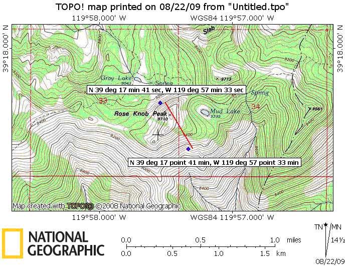
Why does this matter? Let’s look at an example. Suppose you have a GPS and your display says (N 39o17’41”, W 119o57’33”). This reads as (north 39 degrees 17 minutes 41 seconds, west 119 degrees 57 minutes 33 seconds). It places you on the steep slope on the North side of Rose Knob Peak as shown below. But being sleepy, or inexperienced, or careless, or not having practiced, you read this as (39 point 17 point 41, 119 point 57 point 33, or maybe the ever popular (thirty-nine, seventeen, forty-one by one hundred nineteen, fifty-seven, thirty-three)). This is a plausible location for both degrees/minutes/seconds and degrees/minutes/decimal minutes, even though there are too many “points” given and the command post should immediately recognize this and ask you for a corrected location. But if comms are poor, or the other team trying to find you in the sleet is inexperienced or doesn’t know their nav any better than you do, they could easily enter this as degrees/minutes/decimal minutes and end up 600 yards away on the wrong side of the ridge (as shown on the map below)!
If you are not positive about the format a team is using, ask them to specify. AFRCC will almost always send ELT locations in degrees/decimal degrees, as will most cell phone companies. They will always use WGS84 (which is functionally identical to NAD83, and NAD83 is closer to NAD27 on your GPS menu if you have to change back and forth). If the info sender sounds unsure, ask them to be sure to specifically read you all the punctuation in the coordinates such as periods, apostrophes, or quote marks. This is especially true if they give only numbers without ever saying degrees, minutes or seconds. If you get a number bigger than 60, it must be part of a decimal since there are only 60 minutes in a degree and 60 seconds in a minute. If you’re the one reading from your GPS or computer, never say “point” unless there is actually a decimal there on the screen for you to read.
Remember, we use UTM grids and NAD27 datum because all our USGS 7-1/2 minute maps are based on NAD27 and UTM is very user friendly for ground teams. Aircraft are used to using lat/lon, so sometimes we have to be bilingual. Switching back and forth on a GPS in the field can be a headache, especially if you’re switching both datum and coordinate system. To make this simpler: if you are given a WGS84 coordinate and you want to put it on an NAD27 map, just move the mark 80 meters east and 200 meters south. For example, a WGS84 location of 11S 0257500 4381700 would be put on an NAD27 map as 11S 0257580 4381500.
Nevada Gun Rental
TahoeAtv.com